Land Use: Copernicus DEM with Urbanatlas and Corine Land Cover WMS
In this example, a standard cartography map (Urban atlas) is laid over a digital elevation model for better representation of the data in space.
Note
We assume you have set up your environment as described in Setting up Your Own VTS Backend Environment.
Setting up mapproxy resources
For this step, the most important locations are /var/vts/mapproxy/datasets/ where all inputs for mapproxy are stored and
/etc/vts/mapproxy/resource.json where you will place configuration snippet for each mapproxy resource.
During resource preparation it is advisable to turn off the mapproxy, so that you have time to correct mistakes in your configuration:
sudo /etc/init.d/vts-backend-mapproxy stop
As the whole vts-backend runs under the vts user, it is advisable to switch to the vts user so all files are created with the right privileges and ownership.
sudo -iu vts
Preparing workspace
First we create the project directory:
mkdir -p /var/vts/mapproxy/datasets/openlanduse
Input DEM data
The Copernicus programme publishes Digital Elevation Model over Europe (EU-DEM). The EU-DEM is a 3D raster dataset with elevations captured at 1 arc second postings (2.78E-4 degrees) or about every 30 meters.
Data can be downloaded from EU-DEM page. In this example we are going to use the CEE (central and east Europe) region:
- eudem_dem_5deg_n40e010.tif
- eudem_dem_5deg_n40e015.tif
- eudem_dem_5deg_n40e020.tif
- eudem_dem_5deg_n40e025.tif
- eudem_dem_5deg_n45e010.tif
- eudem_dem_5deg_n45e015.tif
- eudem_dem_5deg_n45e020.tif
- eudem_dem_5deg_n45e025.tif
- eudem_dem_5deg_n50e010.tif
- eudem_dem_5deg_n50e015.tif
- eudem_dem_5deg_n50e020.tif
- eudem_dem_5deg_n50e025.tif
- eudem_dem_5deg_n55e010.tif
- eudem_dem_5deg_n55e015.tif
- eudem_dem_5deg_n55e020.tif
- eudem_dem_5deg_n55e025.tif
You should download the data you need and save them in the
/var/vts/mapproxy/datasets/openlanduse/copernicus/rasters directory (do not
forget to mkdir -p
/var/vts/mapproxy/datasets/openlanduse/copernicus/rasters).
Input Open landuse data
Open Land-Use Map is a composite map that is intended to create detailed land-use maps of various regions based on certain pan-European datasets such as CORINE Landcover, UrbanAtlas enriched by available regional data.
Data are published as OGC WMS services.
Setting up DEM dataset
The first thing you need to do after downloading the data is to create a virtual raster with the help of GDAL:
cd /var/vts/mapproxy/datasets/openlanduse/copernicus/rasters
ls

eudem_dem_5deg_n40e010.tif  eudem_dem_5deg_n45e020.tif  eudem_dem_5deg_n55e010.tif
eudem_dem_5deg_n40e015.tif  eudem_dem_5deg_n45e025.tif  eudem_dem_5deg_n55e015.tif
eudem_dem_5deg_n40e020.tif  eudem_dem_5deg_n50e010.tif  eudem_dem_5deg_n55e020.tif
eudem_dem_5deg_n40e025.tif  eudem_dem_5deg_n50e015.tif  eudem_dem_5deg_n55e025.tif
eudem_dem_5deg_n45e010.tif  eudem_dem_5deg_n50e020.tif
eudem_dem_5deg_n45e015.tif  eudem_dem_5deg_n50e025.tif
Let’s create the virtual dataset:
gdalbuildvrt eudem_dem.vrt *.tif
And have a look at the data in QGIS

Note
In this example, we are going to process a major part of Europe. This is
usually very time and resources demanding operation. For some simple
project, make sure your dataset is reasonably sized, e.g., just one country.
For “cutting out” just country borders, use gdalwarp:
gdalwarp -cutline COUNTRY.shp -crop_to_cutline -dstalpha eudem_dem.vrt eudem_COUNTRY.tiff
Next, we have to create virtual overviews:
cd /var/vts/mapproxy/datasets/openlanduse/
mkdir copernicus-dem
generatevrtwo copernicus/rasters/eudem_dem.vrt copernicus-dem/elev --tileSize 1024x1024 --resampling dem
generatevrtwo copernicus/rasters/eudem_dem.vrt copernicus-dem/elev.min --tileSize 1024x1024 --resampling min
generatevrtwo copernicus/rasters/eudem_dem.vrt copernicus-dem/elev.max --tileSize 1024x1024 --resampling max
And as a final step, links named dem, dem.min and dem.max need to
be created:
cd /var/vts/mapproxy/datasets/openlanduse/copernicus-dem
ln -s elev.max/dataset dem.max
ln -s elev.min/dataset dem.min
ln -s elev/dataset dem
And the last preparation step is to create a basic metainformation about tiles - tileindex. For this, we first need to know tile extents of the input dataset:
cd /var/vts/mapproxy/datasets/openlanduse/
mapproxy-calipers copernicus-dem/dem melown2015

2017-08-08 14:43:57 I3 [28036(main)]: [mapproxy-calipers] Config:
    dataset = "/home/jachym/src/melown/projects/openlanduse/datasets/corine/copernicus-dem/dem"
    referenceFrame = melown2015
 {main.cpp:configure():158}
gsd: 24.8558
range<pseudomerc>: 7,15 15/8742,5480:9050,5657
range: 7,15 34,21:35,22
position: obj,15.474967,49.803826,float,0.000000,0.000000,-90.000000,0.000000,649246.827847,55.000000
Now we can run mapproxy-tiling to calculate the tileindex for our input data. Use your own numbers
from range line of mapproxy-calipers output:
mapproxy-tiling copernicus-dem --referenceFrame melown2015 --lodRange 7,15 --tileRange 34,21:35,22
Note
This step can take a very long time, in order to get all the tiles calculated.
Setting up Urban atlas dataset
We are going to rely on the OGC WMS, maintained by European Environment Agency. The service URL is http://image.discomap.eea.europa.eu/arcgis/services/Corine/CLC2012/MapServer/WmsServer. We use GDAL to generate the file needed for MapProxy input:
cd /var/vts/mapproxy/datasets/openlanduse/
gdalinfo "WMS:http://image.discomap.eea.europa.eu/arcgis/services/Corine/CLC2012/MapServer/WmsServer"

    Driver: WMS/OGC Web Map Service
    Files: none associated
    Size is 512, 512
    Coordinate System is `'
    Subdatasets:
      SUBDATASET_1_NAME=WMS:http://image.discomap.eea.europa.eu/arcgis/services/Corine/CLC2012/MapServer/WmsServer?SERVICE=WMS&VERSION=1.1.1&REQUEST=GetMap&LAYERS=Corine%20Land%20Cover%202012%20raster&SRS=EPSG:4326&BBOX=-81.765523,-29.197624,94.141697,72.664410
      SUBDATASET_1_DESC=Corine Land Cover 2012 raster
      SUBDATASET_2_NAME=WMS:http://image.discomap.eea.europa.eu/arcgis/services/Corine/CLC2012/MapServer/WmsServer?SERVICE=WMS&VERSION=1.1.1&REQUEST=GetMap&LAYERS=Corine%20Land%20Cover%202012%20vector&SRS=EPSG:4326&BBOX=-81.231079,-29.121654,93.489511,72.123059
      SUBDATASET_2_DESC=Corine Land Cover 2012 vector
    Corner Coordinates:
    Upper Left  (    0.0,    0.0)
    Lower Left  (    0.0,  512.0)
    Upper Right (  512.0,    0.0)
    Lower Right (  512.0,  512.0)
    Center      (  256.0,  256.0)
We can see there are two subdatasets in the WMS - the Corine Land Cover 2012
raster and the Corine Land Cover 2012 vector. Raster layer is used until
some scale level, then vectors are used, therefore we need to generate an XML containing
both subdatasets. We will take the first one as a base for our
XML template file:
gdal_translate -of WMS "WMS:http://image.discomap.eea.europa.eu/arcgis/services/Corine/CLC2012/MapServer/WmsServer?SERVICE=WMS&VERSION=1.1.1&REQUEST=GetMap&LAYERS=Corine%20Land%20Cover%202012%20vector&SRS=EPSG:4326&BBOX=-81.231079,-29.121654,93.489511,72.123059" corine-landcover.xml
In the file projects/corine/corine-landcover.xml, only the Corine
Land Cover 2012 vector is stored. Let’s open it with a text editor and add the
raster layer too. The result should look similar to this:
4 5 6 | <ServerUrl>http://image.discomap.eea.europa.eu/arcgis/services/Corine/CLC2012/MapServer/WmsServer?SERVICE=WMS</ServerUrl>
<Layers>Corine%20Land%20Cover%202012%20vector,Corine%20Land%20Cover%202012%20raster</Layers>
<SRS>EPSG:4326</SRS>
|
Note the <Layer> element, where both raster and vector layers are
listed.
Having the file in our hand, we can finally configure our datasets.
Configuring Open landuse layer
We shall use the same approach for the Open Landuse layer. The input URL is
http://gis.lesprojekt.cz/cgi-bin/mapserv?map=/home/dima/maps/olu/european_openlandusemap.map
(provided by SDI4Apps project). We will use SUBDATASET_2, Open Land-Use Map, the
layer name is olu.
The final XML can be downloaded projects/corine/openlanduse.xml.
Configuring resources
We can now edit the /etc/vts/mapproxy/resources.json file containing the DEM and Corine
Land Cover datasets. Don’t forget to use mapproxy-calipers to obtain the tile ranges.
[
    {
        "comment" : "corine",
        "credits" : [],
        "driver" : "tms-raster",
        "group" : "openlanduse",
        "id" : "corine",
        "type" : "tms",
        "referenceFrames" : {
            "melown2015" : {
                "lodRange": [2, 24],
                "tileRange": [ [ 0, 0], [1, 1]]
            }
        },
        "definition" : {
            "dataset" : "openlanduse/corine-landcover.xml",
            "format" : "png"
        }
    },
    {
        "comment" : "openlanduse",
        "credits" : [],
        "driver" : "tms-raster",
        "group" : "openlanduse",
        "id" : "openlanduse",
        "type" : "tms",
        "referenceFrames" : {
            "melown2015" : {
                "lodRange": [2, 25],
                "tileRange": [ [ 0, 0], [1, 1]]
            }
        },
        "definition" : {
            "dataset" : "openlanduse/openlanduse.xml",
            "format" : "png"
        }
    },
    {
        "comment": "copernicus",
        "group": "openlanduse",
        "id": "dem",
        "type": "surface",
        "driver": "surface-dem",
        "referenceFrames": {
            "melown2015": {
                "lodRange": [7, 15],
                "tileRange": [ [ 34, 21], [35, 22]]
            }
        },
        "credits": [],
        "definition": {
            "dataset": "openlanduse/copernicus-dem",
            "geoidGrid": "egm96_15.gtx",
            "introspection": {
                "position": ["obj",15.474967,49.803826, "float",0.000000,0.000000,-90.000000,0.000000,649246.827847,55.000000],
                "tms": [
                    {"group":"openlanduse", "id": "corine"}
                ]
            }
        }
    }
]
Alternatively, you can download the complete configuration
projects/corine/resources.json and just replace your resources.json with it.
Running Mapproxy
Mapproxy can be started again using:
sudo /etc/init.d/vts-backend-mapproxy start
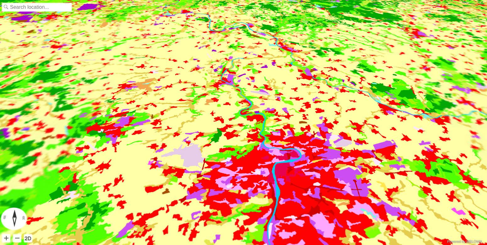
And we should obtain a result similar to the following picture, at http://127.0.0.1:8070/mapproxy/melown2015/surface/openlanduse/dem/
Next steps
Follow Land Use: Adding Legend and Layer Switch to The Map frontend tutorial to learn how to add a legend to the landuse map.